1/3


Wifi Collector
1K+下载次数
2MB大小
1.03(13-04-2019)最新版本

详情评价版本信息
1/3
Wifi Collector介绍
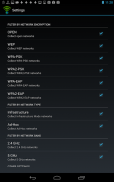
这个应用程序收集有关无线网络和它们的位置信息你在街上行走或驾驶汽车时。
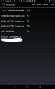
对于每一个无线网络,下面的信息收集:接入点,该公司生产的接入点时,信号电平,信道频率,信道号,安全(WEP/WPA/WPA2),WPS的网络名称(SSID),MAC地址支持(是/否),日期/时间,网络被检测到,并通过无线网络(经度和纬度)的位置取自全球定位系统。
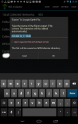
收集的无线网络的信息后,可以将其导出成csv文件,制表符分隔文件,HTML文件,或谷歌地球,它允许查看谷歌地球的地图收集所有网络的位置。KML文件。
此应用程序需要与两个无线组件和GPS设备。
警告!
GPS和wifi的组件由这个应用程序中的用法是相当密集,所以在使用这个应用程序,你的电池将被耗尽比平时快很多。不要忘了点击停止按钮,当你要完成收集的WiFi信息。
Wifi Collector - 版本1.03
(13-04-2019)新特性Added "Don't collect GPS information" option.Fixed to correctly request permissions.

Wifi Collector - APK信息
APK版本: 1.03程序包: net.nirsoft.wificollector名称: Wifi Collector大小: 2 MB下载次数: 673版本: 1.03发布日期: 2024-05-21 01:06:59最小屏幕: SMALL支持的CPU:
程序包ID: net.nirsoft.wificollectorSHA1签名: 7E:34:98:07:71:CA:E5:5E:CA:70:73:9E:51:C3:13:0F:C7:1F:D6:1E开发商 (CN): Nir Sofer组织 (O): NirSoft本地 (L): 国家/地区 (C): 州/市 (ST): 程序包ID: net.nirsoft.wificollectorSHA1签名: 7E:34:98:07:71:CA:E5:5E:CA:70:73:9E:51:C3:13:0F:C7:1F:D6:1E开发商 (CN): Nir Sofer组织 (O): NirSoft本地 (L): 国家/地区 (C): 州/市 (ST):
Wifi Collector的最新版本
1.03
13/4/2019673 下载次数2 MB 大小
其他版本
1.01
27/6/2014673 下载次数943.5 kB 大小
1.00
25/5/2014673 下载次数943.5 kB 大小


同类应用


English


